 |
Hells Canyon Scenic Byway |
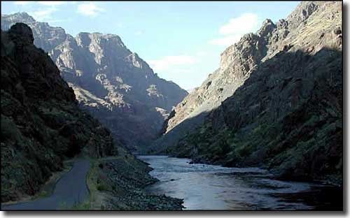 Down in Hells Canyon on the Hells Canyon Scenic Byway |
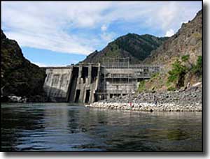
Hells Canyon Scenic Byway is a 22-mile-long route that travels along the eastern edge of the Snake River Canyon, sometimes down in the canyon, sometimes up above. The Snake River here flows along the bottom of a very deep crack in the surface of the Earth between Idaho and Oregon. At the southern end of the byway is the former site of the town of Copperfield on the Oregon side of the Snake River. At the northern terminus of the byway is Hells Canyon Dam (actually, the road crosses the dam and ends at the Hells Canyon Creek Recreation Site, back on the Oregon side of the river). North of Hells Canyon Dam is the Hells Canyon National Recreation Area and the Hells Canyon Wilderness. As beautiful as this drive is, the whole experience isn't complete until you take a guided float trip or jetboat tour down on the river, too. That's the only way you'll be able to crane your neck looking up and come to appreciate the true grandeur of the towering green and black basalt cliffs that drop down or rise up along almost the whole length of the Hells Canyon Scenic Byway. During the summer months, the Visitor Center at Hells Canyon Creek by Hells Canyon Dam is open. In the old days, the area around here was home to Chief Joseph's band of Nez Perce. Other Native Americans who frequented the area were members of the Bannock, Cayuse, Northern Paiute and Shoshone Tribes. The walls of the canyon in this area are resplendent with pictographs and petroglyphs from the days before the European invasion. Hells Canyon Scenic Byway is a narrow, winding road that is maintained (and open) all year round. In good weather figure on taking at least 3 hours to make a round trip. Camping is available at Copperfield Park, Big Bar and Hells Canyon Park. |
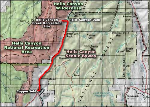 Hells Canyon Scenic Byway area map |
|
|
 |
| Index - Arizona - Colorado - Idaho - Montana - Nevada - New Mexico - Utah - Wyoming National Forests - National Parks - Scenic Byways - Ski & Snowboard Areas - BLM Sites Wilderness Areas - National Wildlife Refuges - National Trails - Rural Life Advertise With Us - About This Site - Privacy Policy |
| Photos of Hells Canyon Scenic Byway courtesy of Idaho Transportation Department. Area map courtesy of National Geographic Topo! Text Copyright © by Sangres.com. All rights reserved. |