 |
Beatty, Nevada |
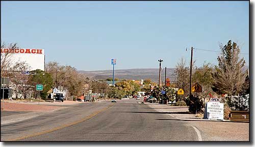 The main thoroughfare in Beatty, Nevada |
|
Beatty is a census designated place located at the junction of US 95 and Nevada Highway 374 (to California via Death Valley National Park). Beatty was originally established as a railway center on the Las Vegas & Tonopah Railroad in the Bullfrog Mining District. The local gold rush started in 1904 with the discovery of gold in the Bullfrog Hills just west of Beatty. Over the next few years more gold strikes happened and places like Gold Center, Transvaal, Rhyolite, Bullfrog and Springdale popped up. A few years later, the ore bodies ran out, the folks left and only Beatty, with its ample supply of water and its location on a major transportation corridor, survived. The Las Vegas & Tonopah Railroad laid tracks and began service to Beatty in 1906. The Bullfrog Goldfield Railroad built their line into town and began regular service in April 1907. Then the Tonopah & Tidewater Railroad reached Beatty and started their regular service in October 1907. Las Vegas & Tonopah lasted until 1918, the Bullfrog Goldfield ended its run in 1928 and the Tonopah & Tidewater ceased operations in 1940. Until the railroads shut down, though, Beatty was the primary railhead in the area for many different mines and served as the economic, cultural and shopping center for a large but very sparsely populated area. The population of Beatty grew slowly from 169 in 1929 to 485 in 1950. Electricity didn't really arrive in Beatty until it was brought in by the Amargosa Power Company in 1940. Sometime during World War II is when Beatty got telephones and the community septic system wasn't installed until the 1970's. Through all this time, tourism was slowly picking up. Nevada legalized gambling in 1931. The Death Valley National Monument was opened in 1933. And as the prominence of Las Vegas rose, Beatty started to see more business flowing through. Other additions to the local economy stem from nearby Nellis Air Force Base and Range and the Nevada Test Site. A low level radioactive waste disposal site opened up about 17 miles south of Beatty in 1962 and was accepting radioactive waste up until 1992. In 1970 that same disposal site began accepting hazardous chemical waste for burial and is still receiving those materials. Near that site the United States Geological Survey operates the Amargosa Desert Research Site to study arid-land hydrology. From 1988 to 1998 gold was being extracted from a site on the south side of Ladd Mountain, west of Beatty, that came to be known as the Barrick Bullfrog Mine. The federal Environmental Protection Agency named that site as one of six to be used for pilot reclamation projects under the national Brownfields Mine-Scarred Land Initiative in 2004. Then the Beatty Economic Development Corporation got involved and suggested using the polluted site for solar-power generation. Some of the funds from the 2009 American Recovery and Reinvestment Act are apparently slated to finance part of that project. According to a story in the New York Times: "Studies show that the Beatty area has some of the best solar energy potential in the United States, as well as a high potential for wind-power generation." |
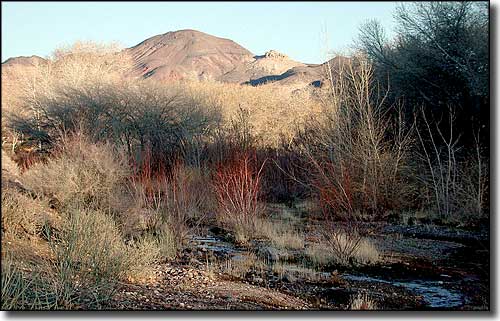 The Amargosa River in Beatty 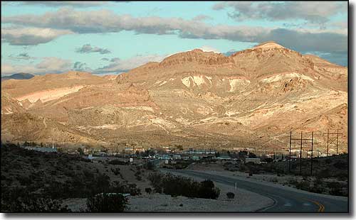 Beatty Mountain rising above the town of Beatty |
| Fast Facts about Beatty, Nevada |
|
Beatty, Nye County, NV 89003
Founded: 1905 Elevation: 3,307' Latitude: 36.9093°N Longitude: 116.7545°W Resident Racial Breakdown: White Non-Hispanic: 84.3% Hispanic: 8.5% Two or More Races: 7.2% Education: High School or Higher: 82.1% Bachelor's Degree or Higher: 7.7% Graduate or Professional Degree: 2.7% 2009 Estimates: Population: 1,545 Males: 840 Females: 705 Median Resident Age: 40.5 Years Estimated Median Household Income: $24,990 Estimated Median Home Value: $56,560 2011 Cost of Living Index for Beatty: 88.0 Major Industries: Entertainment & Recreation, Mining, Educational Services, Lodging & Food Services, Professional Services, Construction, Transportation Equipment & Services, Government Unemployed: 17.1% |
|
|
Nye County Related Pages
Amargosa Valley - Gabbs - Manhattan - Pahrump - Round Mountain - Tonopah - Nye County
Berlin-Ichthyosaur State Park - Belmont Courthouse State Historic Park Extraterrestrial Highway - Lunar Crater Back Country Byway Other Nye County Related Pages
Humboldt-Toiyabe National Forest - Alta Toquima Wilderness - Arc Dome Wilderness
Ash Meadows NWR - Currant Mountain Wilderness - Grant Range Wilderness Quinn Canyon Wilderness - Table Mountain Wilderness Nevada Pages |
 |
| Index - Arizona - Colorado - Idaho - Montana - Nevada - New Mexico - Utah - Wyoming National Forests - National Parks - Scenic Byways - Ski & Snowboard Areas - BLM Sites Wilderness Areas - National Wildlife Refuges - National Trails - Rural Life Advertise With Us - About This Site - Privacy Policy |
| Upper photo of Beatty, Nevada is courtesy of Gary Edstrom, CCA 3.0 License Photo of the Amargosa River and lower photo of Beatty courtesy of Finetooth, CCA ShareAlike 3.0 License. Text Copyright © by Sangres.com. All rights reserved. |