Sangres.com logo

Selected Hiking Trails in Colorado

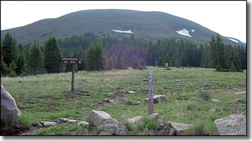
Greenhorn Mountain

Two long-distance hiking trails of national importance pass through southern Colorado: the Colorado Trail and the Continental Divide National Scenic Trail. The Colorado Trail is a 469 mile trail between Denver and Durango. The 3,100 mile Continental Divide Trail is proposed between the Mexican and Canadian borders. Numerous side trails connect these two trails with campgrounds, trailheads and local communities along the way.

The Colorado Trail is open to hikers, horseback riders and cross-country skiers. Mountain bikes are currently permitted on the non-Wilderness segments of the trail. The trail passes through seven National Forests, six Wildernesses, five major river systems, and eight mountain ranges. The trail is even more impressive because it was created through a massive volunteer effort involving thousands of trail-building enthusiasts. The Colorado Trail is jointly administered by the Colorado Trail Foundation and the US Forest Service.

The 3,100 mile Continental Divide National Scenic Trail, when completed, will provide spectacular backcountry travel the length of the Rocky Mountains from Mexico to Canada. It is the most rugged of the long distance trails. The trail was designated in 1978 and is designed to be an educational as well as a hiking experience. The trail traverses a variety of terrain, including high desert, forests, geologic formations, and mountain meadows. Along the way travelers can catch glimpses of a variety of historical, cultural and scenic landscapes, as well as abundant wildlife. Hiking opportunities range from short leisurely hikes to challenging alpine and desert segments.

The BLM Lands and the National Forests of Colorado are also full of hiking trails. Some of them are old mining or logging roads, others are jeep trails. It seems that both the BLM and the Forest Service have a no-maintenance policy in effect when it comes to roads. There are some roads that see a lot of travel that are well taken care of, there are others that haven't been touched in many a summer. There's good and bad to this. If the road has been gated, chances are good that you won't run into any vehicular traffic on your hike. If the road is not gated, you're taking your chances in terms of running into vehicles along the way (see On 4WD Vehicles in the Wilderness). On the other hand, some of these old roads are now just trails that fade in and out of the wilderness as you travel them. In some respects, they make it easier to get where you want to go without impacting the countryside or the scenery any more heavily than it is already hit.

Selected Hiking Trails

Barr National Recreation Trail (TR 620) - Pike National Forest - 11.7 miles
This trail constructed by Fred Barr between 1914 and 1921 is the most popular hiking trail to the top of Pike's Peak. With views of the Crater and the Bottomless Pit, this long sustained grade to high elevation makes for a difficult climb. The average round trip takes 16 hours. Elevation Gain: 7,390 feet.

Bear Creek National Recreation Trail (TR 241) - Uncompahgre National Forest - 7 miles
This is a former mining route with interesting geological formations and several mine ruins along the way. The trail is quite steep in places and features many switchbacks near the beginning. Elevation Gain: 4,100 feet.

Braille Trail - White River National Forest - 0.25 miles
Designed to provide blind hikers with a complete outdoor experience, there are 22 signs along the trail with messages in Braille as well as print. There are nylon cord guides also.

Byer's Peak Trail (TR 15) - Arapaho-Roosevelt National Forest - 2.4 miles
This is a short but steep hike with spectacular views from Byer's Peak. With parking and a trailhead off of FR 111, this trail travels through a rich forest of virgin timber including spruces and firs. Elevation Gain: 2,025 feet.

Climbing Mt. Harvard - San Isabel National Forest - 8.5 miles
This route follows the Harvard Trail for 4.5 miles to the intersection with the Colorado Trail, which it crosses and continues up the Frenchman Creek drainage for 2.5 miles. The last 1.5 miles travels along the ridge to the summit of Colorado's 3rd highest peak, 14,420 feet. Elevation Gain: 6,020 feet.

Colorado Trail - Kassler - 470 miles
This multiple use, volunteer built trail crosses the state from Denver to Durango, passing through 7 national forests and 6 wildernesses along the way. Detailed trail information is available from the Colorado Trail Association, PO Box 260876, Lakewood, CO 80226.

Columbine Lake Trail (TR 11) - Arapaho-Roosevelt National Forest - 2.8 miles
This is an easy hike through boggy, verdant meadows with waterfalls and several rock formations along the route to the lake on top of the plateau and views of the Continental Divide peaks. Elevation Gain: 980 feet.

Continental Divide National Scenic Trail - Routt National Forest - 600 mile route
When complete, this trail will extend the length of the Continental Divide with over 600 miles in Colorado. While much of the Trail is already in place, Congress has yet to give it an official designation. - For more info: Continental Divide Trail Alliance.

Conundrum Trail (TR 1981) - White River National Forest - 13 miles
The trailhead is 1.5 miles down a gravel road off of Castle Creek Road. This popular, moderately difficult trail crosses Conundrum Creek twice before reaching the hot springs nine miles in. Past the spring, the trail goes to Copper and Triangle Passes. Elevation Gain: 4,000 feet.

Crag Crest National Recreation Trail (TR 711) - Grand Mesa National Forest - 10 mile loop
This circular trail atop Grand Mesa offers many scenic vistas and unique displays of geological history. Moderately strenuous, there are some narrow sections with steep dropoffs on both sides. Elevation Gain: 1,039 feet.

Curecanti Creek Trail - Curecanti National Recreation Area - 2 miles
This trail quickly descends from the rim of the Black Canyon of the Gunnison to Morrow Point Lake by following the course of the fast-flowing Curecanti Creek. At the trail's end you get good views of the Curecanti Neddle, a 700-foot granite spire. Elevation Loss: 900 feet.

Devil's Head National Recreation Trail (TR 611) - Pike National Forest - 1.3 miles
This high use but intermediate difficulty trail leads to a massive granite outcropping and the Devil's Head Fire Lookout, the last operative fire lookout on the Front Range. The last 200 feet to the summit is on stairways. Great views of the surrounding forest and the plains to the east. Elevation Gain: 948 feet.

East Bellows Creek Trail (TR 790) - Rio Grande National Forest - 8 miles
This is a long day hike leading into the Wheeler Geologic Area and Halfmoon Pass on the Continental Divide. The trail follows an old jeep road and crosses East Bellows Creek. Elevation Gain: 1,900 feet.

Fish Creek Trail (TR 1102) - Routt National Forest - 10.5 miles
The first section of this trail to Fish Creek Falls is wide and smooth with interpretive signing. After crossing the creek, the trail climbs steeply up and out of the canyon. Several lakes and subalpine meadows near the Continental Divide make this area especially attractive to backpackers. Elevation Gain: 2,260 feet.

Fourmile Falls Trail (TR 579) - San Juan National Forest - 3 miles
This relatively easy trail follows Fourmile Creek into the Weminuche Wilderness by going between Pagosa Peak and Eagle Mountain to the falls and Fourmile Lake.

Greyrock National Recreation Trail (TR 946) Arapaho-Roosevelt National Forest - 3.5 miles
This trail rises steadily from Poudre Canyon to the summit of Greyrock Mountain with great views of the Front Range peaks and the plains to the east. The adjoining Greyrock Meadow Loop adds 2.3 miles to the hike and offers viewpoints into the canyon. Elevation Gain: 2,040 feet.

Hanging Lake Trail (TR 1850) - White River National Forest - 1.2 miles
This is a steep trail with spectacular views of Dead Horse Creek and Glenwood Canyon on the way to phenomenal Hanging Lake. Fragile environment: no fishing or swimming. Elevation Gain: 1,000 feet.

Harper's Corner Nature Trail - Dinosaur National Monument - 1 mile
This short interpretive trail offers views of the Green River and Whirlpool Canyon. Elevation Loss: 115 feet.

Herman Gulch Trail (TR 98) - Arapaho-Roosevelt National Forest - 2.5 miles
The first section of this trail follows an old jeep road out of the forested area and into subalpine fields of wildflowers. After 1.5 miles, the trail rises above timberline and follows rock cairns to Herman Lake. There are numerous places to camp along this moderately difficult trail. Elevation Gain: 1,600 feet.

Hermosa Creek Trail (TR 514) - San Juan National Forest - 20 miles
This easy trail follows the long canyon of Hermosa Creek with several long and short variations possible. While the southern end of the trail is the most heavily used, there is access to fishing and hunting all along the route. Elevation Gain: 1,200 feet.

Main Dune Mass Climb - Great Sand Dunes National Park - various routes
While there are no established trails on the sand dunes, general trekking is allowed: shoes, water and sunscreen are advised. You might even some of the several rare animal species that inhabit the area. Use caution when walking on the dunes: lightning is common and very dangerous. Elevation Gain: 700 feet.

Mill-Castle Trail (TR 450) - Gunnison National Forest - 14.3 miles
This trail goes into the West Elk Wilderness and over Storm Pass. Lots of rock formations and wildlife to see. This moderate to difficult hike is very steep on both sides of the pass. Elevation Gain: 3,450 feet.

Monument Canyon Trail - Colorado National Monument - 6 miles
This backcountry hike of intermediate difficulty makes a steep descent from the plateau into Monument Canyon where many of the park's major rock sculptures - Independence Monument, Kissing Couple and Cike Ovens - tower overhead. Elevation Loss: 600 feet.

Mosca Pass Trail - Great Sand Dunes National Park - 3.5 miles
This hike along Mosca Creek leads through pinons, junipers, aspens, and spruces up to the summit of Mosca Pass. Great views of San Luis Valley and lots of wildlife. Elevation Gain: 1,463 feet.

Mt. Garfield Trail - BLM Grand Junction Recreation Management Area - 2 miles
This fairly steep trail leads to the mountaintop and great views of the Book Cliff Range to the west. Carry lots of water. Elevation Gain: 1,965 feet.

Neversink Trail - Curecanti National Recreation Area - 0.5 miles
This flat streamside walk leads past a great blue heron rookery. With a heavy undergrowth of grasses, flowers and trees, this area is ideal for birding and wildlife observation.

North Chasm View Trail - Black Canyon of the Gunnison National Park - 0.7 mile loop
The trailhead is at the North Rim Campground. This easy loop trail leads to overlooks atop one of the highest sheer vertical walls in the state.

North Vista Trail - Black Canyon of the Gunnison National Park - 3.5 miles
This moderately difficult wilderness trail leads to Exclamation Point with spectacular views of the Gunnison River and Green Mountain. /the trailhead is at the North Rim Ranger Station. Elevation Loss: 800 feet.

Oak Flat Trail - Black Canyon of the Gunnison National Park - 1.5 mile loop
This is a loop trail along the rim of the canyon through expanses of Douglas Fir and aspen with great views of the Gunnison River below. The trailhead is at the Gunnison Point Visitor Center. Elevation Difference: 300 feet.

Overlook Trail (TR 641) - Pike National Forest - 0.5 mile
This easy day hike offers views of Elevenmile Canyon (but no access) and occassional sightings of golden eagles. Elevation Gain: 500 feet.

Pawnee Buttes Trail (TR 840) - Pawnee National Grasslands - 2 miles
This short, easy hike is best in the springtime when the wildflowers are in bloom. The parking lot and trailhead are next to a large windmill. Elevation Gain: 240 feet.

Petroglyph Point Trail - Mesa Verde National Park - 2.8 mile loop
This loop trail begins at Spruce Tree House and travels south below the edge of the plateau before making a short climb to the rim and returning to the trailhead. Good views of Navajo and Spruce Canyons and petroglyphs. Register at the ranger's office before starting out. Elevation Gain: 330 feet.

Prater Ridge Trail - Mesa Verde National Park - 7.8 mile loop
This trail of intermediate difficulty ascends the east side of Prater Ridge and loops around the top of the ridge before returning via the same route. Panoramic views of the countryside with many changes in elevation and vegetation types along the way. No permit required.

Rabbit Valley Interpretive Trail - BLM Grand Junction Recreation Area - 1.5 mile loop
This “Trail through Time” self-guided tour is a moderately strenuous interpretive loop through an area rich in fossil history, including dinosaurs.

Rainbow Trail - San Isabel National Forest - 100 miles
Named for its' reminiscent shape, this trail extends along the eastern side of the Sangre de Cristo Mountains with several side trails, a wide variety of terrain and some excellent viewpoints.

Round Mountain National Recreation Trail (TR 831) - Arapaho-Roosevelt National Forest - 4.5 miles
This day-use trail leads to the summit of Sheep Mountain. The trailhead and parking lot are 3 miles from US 34. No camping is allowed. Elevation Gain: 2,250 feet.

Serpent's Trail - Colorado National Monument - 2.3 miles
This historic trail, called “the crookedest road in the world,” has more than 50 switchbacks in less than 2.5 miles. Built by John Otto in the early 1900's, the route features spectacular views of canyon country.

South Mt. Elbert Trail (TR 1481) - San Isabel National Forest - 6 miles
This is a strenuous hike to the top of Colorado's highest mountain (14,433 feet). The route follows the Colorado Trail for the first 3 miles, then veers northwest to the summit. Expect snowfields and spectacular views but carry lots of water. Elevation Gain: 4,811 feet.

Uncompahgre Peak Trail (TR 239) - Uncompahgre National Forest - 5 miles
This moderate to difficult hike offers high altitude alpine tundra and spectacular views of several peaks over 13,000 feet. This is the primary access route into the Big Blue Wilderness and to Uncompahgre Peak (14,309 feet). Elevation Gain: 2,859 feet.

Wager Gulch Trail - BLM Gunnison Recreation Area - 4.8 miles
The first 1.5 miles of this trail are rather steep before it levels out as it approaches the privately-owned ghost town of Carson. From Carson the trail climbs another 1.4 miles to the Continental Divide. Elevation Gain: 3,100 feet.

West Lost Trail (TR 822) - Rio Grande National Forest - 6.1 miles
Hike about 1.75 miles up the Lost Creek Trail (TR 821) to the junction of Lost Trail and West Lost Trail Creeks. It's an easy hike from there to the Continental Divide. This is a very scenic trail with lots of wildlife. Elevation Gain: 2,050 feet.

Rocky Mountain National Park

Black Lake Trail - 4.7 miles
Use the Glacier Gorge Trailhead. The trail follows the Loch Vale Trail until Glacier Knobs, where it turns south and continues past Mills Lake alongside the Glacier Gorge drainage to Black Lake. This is a difficult hike, especially in the area between Mills and Black Lakes. Elevation Gain: 1,380 feet.

Cascade Falls Trail - 3.5 miles
Use the North Inlet Trailhead located just north of Grand Lake near the Kawuneeche Visitor Center. This gentle climb to Cascade Falls is generally snow-covered late in the season. Elevation Gain: 300 feet.

Dream Lake Trail - 1.1 miles
This easy and popular scenic hike starts at Bear Lake, climbs gently to Nymph Lake, Dream Lake and finally, to Emerald Lake. Elevation Gain: 425 feet.

East Longs Peak Trail - 8 miles
This is a difficult trail for experienced hikers/climbers only. The trail climbs first into the Boulderfield and then onto the Keyhole route: a steep ledge system where the difficulty intensifies. Continue on through the Trough (a large couloir) to the Narrows and then the Homestretch. Average time for roundtrip: 15 hours. Elevation Gain: 4,855 feet.

Eugenia Mine Trail - 1.4 miles
This easy walk to an abandoned mine offers a change of pace from other area trails. Elevation Gain: 500 feet.

Fern Lake Trail - 8.5 miles
This intermediate difficulty trail starts at the Bear Lake Trailhead and goes downhill for most of its route, passing Fern Lake, Odessa Lake and crossing the saddle between 2 mountain peaks. Elevation Loss: 1,865 feet.

Lawn Lake Trail - 6.2 miles
This strenuous hike from Endovalley Road to Lawn Lake along the Roaring River offers a steady ascent into the Mummy Range with great views of Mummy Mountain. Elevation Gain: 2,249 feet.

Lulu City Trail - 3.1 miles
This trail for intermediate hikers begins at the Colorado River Trailhead near the western boundary of the park. It leads into former mining areas such as the Shipler Mine and Lulu City. Elevation Gain: 300 feet.

North Longs Peak Trail - 9.5 miles
Starting at the Glacier Gorge Trailhead, this trail follows the Loch Vale Trail for 1 mile before turning left at the fork. The trail then continues for 5 miles before joining the East Longs Peak Trail at Granite Pass and following the same route to the summit. This strenuous trail is for experienced hikers/climbers only. Winter conditions exist here for most of the year. Elevation Gain: 5,015 feet.

Ouzel Falls Trail - 2.7 miles
This trailhead is located in the generally less crowded area at Wild Basin Ranger Station. This moderate hike passes the site of the 1978 Ouzel fire and continues up to the waterfall. Elevation Gain: 950 feet.

Timber Lake Trail - 4.8 miles
On this trail for experienced backpackers you can find a variety of terrain: from marshy meadows to timberline lakes to alpine tundra. Elevation Gain: 2,060 feet.

Uncompahgre Wilderness
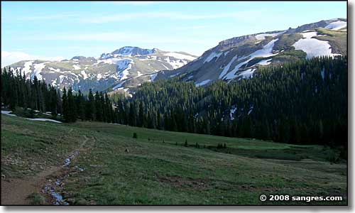
Matterhorn Trail, Uncompahgre Wilderness
sangres.com logo
Photos courtesy of Sangres.com, CCA ShareAlike 3.0 License.
All text Copyright © by Sangres.com. All rights reserved.