 |
Lewiston, Idaho |
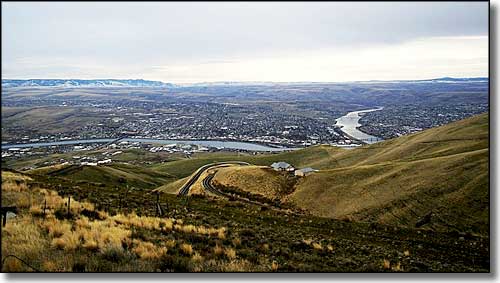 Looking over Lewiston from the north |
Obviously, Lewiston in Idaho and Clarkston in Washington were both named for the principals of the Lewis & Clark Expedition of 1804-1806. Lewiston is located at the confluence of the Snake and Clearwater Rivers, just north of Hell's Gate State Park. The main industry in Lewiston for many years has revolved around the production of paper and timber products. As the Snake River is navigable by some ocean-going vessels between Lewiston and the confluence with the Columbia River near Pasco, Washington, Lewiston is also Idaho's only seaport. Barges of grains, timber products, paper products and other goods are shipped from here to the Pacific via the Snake-Columbia River system. The Lewis & Clark Expedition met members of the Nez Perce Tribe in this vicinity in 1805. Several other expeditions that followed the river system came through in later years but the main portion of the Oregon Trail (when that became established) was much further to the south. A local gold rush started in 1860 and Lewiston was founded the next year. Idaho's first newspaper began publication in Lewiston in 1862 and Lewiston became the Idaho Territorial Capital in 1863 (but that was moved to Boise in 1865). The first gold rush in Idaho was in the wilderness around the Clearwater and Salmon Rivers to the east. At first, Lewiston was a booming tent city on the Nez Perce Reservation. In 1863 a new treaty was negotiated with the Nez Perce that placed the site of Lewiston outside the reservation. However, the pressure to build permanent structures dropped off because gold was discovered in the Boise Basin further south. The population of Lewiston dropped from several thousand to about 300, almost overnight. Then the Territorial Legislature voted to move the capital to Boise. After the gold rush, life in Lewiston settled down a bit and growth was probably more healthy. The surrounding area developed into an agricultural region and Lewiston, as the nearest seaport, prospered. For about 80 years, the countryside around Lewiston was dotted with small settlements supplied by the businesses in Lewiston, but as methods of transportation evolved and improved, many of these small towns were abandoned and everything (and everyone) slowly moved back to Lewiston. |
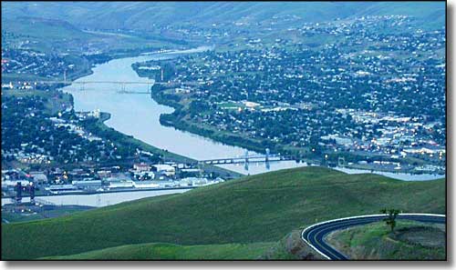 Lewiston, Idaho on the left, Clarkston, Washington on the right |
| Fast Facts about Lewiston, Idaho |
|
Lewiston, Nez Perce County, ID 83501
Incorporated: 1861 Elevation: 745' Latitude: 46.4002 Longitude: 117.001 Resident Racial Breakdown: White Non-Hispanic: 91.7% Hispanic: 2.8% Asian: 1.4% Native American: 1.1% African-American: 0.2% Other: 0.1% Two or More Races: 2.8% Education: High School or Higher: 86.2% Bachelor's Degree or Higher: 19.6% Graduate or Professional Degree: 5.6%
2009 Estimates: Population: 31,887 Males: 15,562 Females: 16,325 Median Resident Age: 37.9 Years Estimated Median Household Income: $40,900 Estimated Median Home Value: $142,500 Population Density: 1,933 People per Square Mile 2011 Cost of Living Index for Lewiston: 89.3 Major Industries: Health Care, Paper Products, Lodging & Food Services, Construction, Educational Services, Government, Finance & Insurance Services, Metal & Metal Products, Social Services Unemployed (March 2011): 8.4% |
|
|
 |
| Index - Arizona - Colorado - Idaho - Montana - Nevada - New Mexico - Utah - Wyoming National Forests - National Parks - Scenic Byways - Ski & Snowboard Areas - BLM Sites Wilderness Areas - National Wildlife Refuges - National Trails - Rural Life Advertise With Us - About This Site - Privacy Policy |
| Upper photo of Lewiston, Idaho courtesy of Dk4hb, CCA ShareAlike 3.0 License. Text Copyright © by Sangres.com. All rights reserved. |