Information about Sangres.com
Sangres.com began as a personal website, an area information and education site I started putting together back in 1998 when I was first learning HTML. I still treat this project as a personal site but it's getting kinda large: nothing like having an interesting hobby get out of hand and start to take over your life. However, feeding the continuous growth of this thing requires me to spend more time in the countryside than at my monitors and that is a healthy change for me: I came to the Colorado mountains for the world-class outdoor lifestyle in the first place.
I've also seen this site turn into a vacation planner and relocation resource for folks because once I arrive somewhere, I tend to take lots of photos and gather data about things that interest myself and would, hopefully, interest other visitors and potential new residents to the area. And as time goes on, I analyze my stats and then I return to areas that get a lot of Internet attention to expand my data and add more photos. I also use what I learn here and from other sources on the web in support of my other "day job": Paradox Web Resources.
I recently filed the IRS paperwork necessary to turn Paradox Web Resources and Sangres.com into a non-profit organization (Section 501(c)(3)). I did that because I'm getting more and more involved in promoting handicapped accessibility on the web and as a non-profit entity, I would have access to other sources of funding that would allow me to participate in that promotional activity more freely and fully. To that end, I am collaborating with several other webmasters in the formation of the Level 5 Independent Publishers Group, with a site designed to offer "do it yourself" info in regards to increasing handicapped accessibility and to build a directory of accessible websites.
My Photo Disclaimer: (not really but...) When I drive into a town, I'm looking for the historical stuff, the "original" stuff that catches my eye. I'm not looking for the shopping centers or malls - these things look like "Anywhere, USA." I want to showcase the things that make these Intermountain States unique. So some places in these states I simply pass on: whoever drew up the master development plan worked for a major developer and there is no "town," it's just a bunch of residental stuff closely connected to the shopping mall, or center, or village, or whatever they call it. And some of the places I drive into are simply a dot on the map: there used to be something there but whatever it was, it's faded away over time and there may be only foundations and piles of rubble left. These "ghost towns" I usually take lots of photos of because they are unique to the true character of the old West. Then there's the places in between...
Sometimes I'm asked why I put so much data in about local businesses (the local services pages in particular). These business listings get me more attention from the big search engines and attract more traffic. The Google AdBots read these pages to deliver properly targeted ads to them (although this can be a "Catch 22" set up: for example, the page for "Alferd Packer, the Cannibal of Lake City" was getting ads for weight loss clinics - and the judge at Packer's trial is quoted as saying, "There were seven Democrats in Hinsdale County, and you ate five of them," - so I removed most of the ads from the page). And while nearly every page on this website is used as an entry page by someone, the "Towns and Places" pages and the local business listing pages attached to them account for about 50% of my traffic. If you are a business owner interested in sponsoring this site, please go here and check out the potential benefits to you and your business. I'm offering some very cost-effective solutions as I move to reduce my reliance on Google (and others) for monetization. And as this site grows, I get more and more traffic interested in visiting here, moving here, doing business here. It's a win-win for all of us.

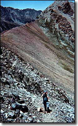
The photo to the left is me taking a photo of my climbing partner while he's taking a photo of me on the side of Mt. Lindsey. That's the Iron Nipple in the upper right corner and, across the Upper Huerfano Valley, Zapata Ridge leading north from California Peak in the upper left corner.
Some of the data, photos, images, and other maps on this site are courtesy of various Federal (NFS, USGS, NPS, etc.), State and Chambers of Commerce brochures. Some is courtesy of various state historical societies. Wherever this type of info is used, I try to remember to give credits on that page. Virtually everything else is of my own creation, although there are individual elements that are credited on certain pages.
Some of the relief maps/satellite imagery on the site are derived from Cartesia Software's MapArt US Terrain. There's also some topographic maps from TOPO!, part of the National Geographic Back Roads Explorer package: nationalgeographic.com/maps.
Most of the maps presented on this site are courtesy of Google Maps. The Google Maps have excellent panning and zooming capabilities, too, and that's hard to beat, especially when you can click on a button and add satellite imagery or terrain mapping to the view.
Every effort has been made to ensure accuracy in the directories included on this website, however, I (the publisher) cannot guarantee the correctness of all information available, or the complete absense of errors, omissions or unintentional inclusions.
The "To reach me" link on the very bottom of this page feeds to the one contact page I run on this site: if you feel you really need to contact me, this one works.


