 |
Bear Lake National Wildlife Refuge |
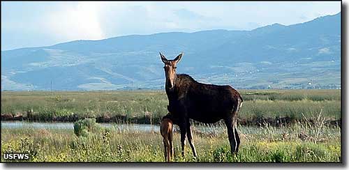 Cow and calf moose in the Rainbow Unit at Bear Lake National Wildlife Refuge |
|
Bear Lake National Wildlife Refuge is a 19,000-acre property that includes most of the Dingle Marsh (or Dingle Swamp, as some of the local folks call it). The Dingle Marsh is a mix of openwater, bulrush marsh and flooded meadows of rushes, native grasses and sedges. Most of the Bear Lake NWR is in the valley at 5,295', but it rises up on the slopes of Merkley Mountain to about 6,800'. The upper reaches of the property are mostly brush covered slopes and scattered grasslands. In prehistoric times, Bear Lake extended through the whole valley but as the lake drained and receded, the low areas to the north turned into swampy marsh. Today, this is some of the finest waterfowl resting and nesting area in Idaho. The marsh area is a mix of open water, bulrush marsh and flooded meadows of rushes, sedges and grasses. The uplands area is a mix of brush-covered slopes and scattered grasslands. The refuge cuts hay and then floods the hayfields in the spring to provide nesting and feeding areas for ibis, sandhill cranes and waterfowl. Several fields around the marsh are also planted in barley and alfalfa for the cranes and the waterfowl. The barley and alfalfa fields are visited every year by up to 500 sandhill cranes and up to 1,000 Canada geese. The refuge is managed to provide optimum breeding and nesting habitat for 6 specific species: Canada geese, trumpeter swans, white-faced ibis, sandhill cranes, and canvasback and redhead ducks. Several fields around the edges of the marsh are cultivated to grow alfalfa and barley for the waterfowl and cranes. In a typical nesting season, Bear Lake NWR will produce 4,500 ducks and 1,800 geese. Canvasback, redhead, mallard and gadwall ducks, plus northern shoveler and cinnamon teal also use the refuge for nesting. Usually in the bulrushes you'll find double-crested cormorant, black-crowned night heron, great blue heron, snowy egret, white-faced ibis, Franklin's gull, California gull, Forster's tern, black tern, Caspian tern, eared grebe and western grebe. The Dingle Marsh area provides enough differing habitat to appeal to more than 160 different species of birds. The sandhill cranes make their presence felt most in late September when they descend on the refuge grainfields. You might see between 200 and 500 of them at a time. Bear Lake NWR also harbors one of the largest nesting colonies of the now-rare white-faced ibis. The Thomas Fork Unit is a separate 1,015-acre tract of land managed by Bear Lake NWR but located about 20 miles east of Montpelier against the Wyoming State line. Elevation of the property is approximately 6,060' and access is via US Highway 30. This property is along the Bear River (ideal waterbird country) and very close to the Cokeville Meadows National Wildlife Refuge in Wyoming. Artifacts found in the area indicate the Shoshone and Bannock Indians used this area for grazing horses and buffalo hunting. Scattered through the marsh are clumps of old buffalo skulls and bones. In the early 1900's, ranchers using Bunn Island for growing hay had to remove large amounts of buffalo bones before they could cut the hay. Summers at Bear Lake rarely see temperatures above 90°F during the day while it almost always cool off into the 40's at night. The property is generally covered in snow from mid-November through mid-April. The roads that encircle the refuge and those found in the northern end of the property are usually available for vehicular use. The Salt Meadow Unit Wildlife Observation Route is open for vehicles and foot travel except when snow makes it impassable. There are two wildlife photography blinds available to the public between March 15 and September 20. Hiking is allowed on all roads open to vehicles. General hiking on the property is allowed in those areas of the map marked "Seasonally Open." Horseback riding is allowed only on those roads and trails specifically marked on the map. The universally accessible hiking trail is open from March 15 through September 20. Cross-country skiing and snowshoeing are allowed on every trail and road that allows hiking. Boating is limited to those areas marked on the map for boating. In addition, motorized and non-motorized boats are limited to the time period from September 20 through January 15. The Canoe Trail is open from July 1 through September 20. There are private campgrounds in the area and public campgrounds available in Caribou National Forest. Camping is not allowed at Bear Lake National Wildlife Refuge. Fishing is allowed only in the area immediately north of the Lifton Pumping Station and in the north portion of the Outlet Canal. However, just because fishing is allowed doesn't mean the fishing is "good," it's actually much better in the streams of the nearby mountains and on Bear Lake proper. To get there: the office is in Montpelier, just go east off Route 30 in Montpelier on Webster Street. To get to the refuge: West of Montpelier on US Highway 89, about halfway between Montpelier and Ovid you'll find a marked gravel road going south. Follow that for about 5 miles to the refuge boundary. US Highway 89 to the west of Bear Lake NWR is also part of the Bear Lake-Oregon Trail Scenic Byway. |
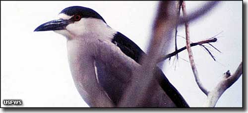 A black-crowned night heron at Bear Lake NWR 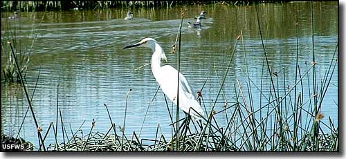 An egret surveying its domain... 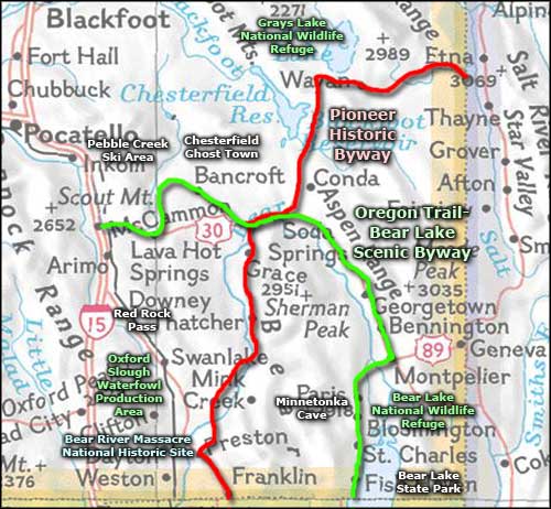 Bear Lake National Wildlife Refuge area map |
|
|
 |
| Index - Arizona - Colorado - Idaho - Montana - Nevada - New Mexico - Utah - Wyoming National Forests - National Parks - Scenic Byways - Ski & Snowboard Areas - BLM Sites Wilderness Areas - National Wildlife Refuges - National Trails - Rural Life Advertise With Us - About This Site - Privacy Policy |
| Photos courtesy of the US Fish & Wildlife Service. Area map courtesy of National Geographic Topo! Text Copyright © by Sangres.com. All rights reserved. |