 |
|
|
Sawtooth National Forest Campgrounds
|
|
|
|
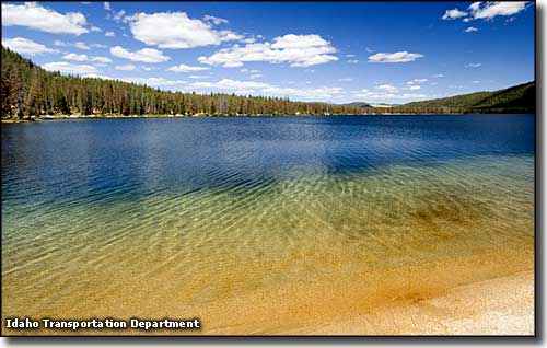
Stanley Lake
|
| North Fork Canyon |
| Campground |
# of Units |
Comments: R=Reserve; P=Picnic; C=Campground |
| North Fork |
29 |
|
| Wood River |
30 |
|
| Easley |
10 |
C & R |
| Boulder View |
Group Area A- 3 sites
Group Area B - 5 sites |
C & R |
| Wood River Picnic Area |
- |
Day use only |
| Alturas Lake Area
|
| Campground |
# of Units |
Comments: R=Reserve; P=Picnic; C=Campground; Comments |
| North Shore |
15 |
|
| Smokey Bear |
12 |
Boat trailer parking & ramp |
| Alturas Lake Inlet |
28 |
Day use picnic and beach areas |
| Alturas Lake Picnic Area |
Area A & B |
P & R |
| Sandy Beach Picnic & Day Use Area |
- |
P |
| Chemeketan |
- |
C & R: Group Reservations. No Water. Limit size is 150 |
| Pettit Lake |
13 |
Water & toilets available at Tin Cup |
| Redfish Lake Area |
| Campground |
# of Units |
Comments: R=Reserve; P=Picnic; C=Campground; Comments |
| Chinook Bay |
13 |
Little Redfish Lake |
| Mountain View |
7 |
Little Redfish Lake |
| Sunny Gulch |
19 |
Off Highway 75 |
| Sockey |
23 |
|
| Mt Heyburn |
20 |
|
| Glacier View |
Loop A - 26 units
Loop B - 17 units
Loop C - 22 units |
C & R |
| Outlet |
17 |
C & R |
| Point |
17 |
C & R: Units 1-8 are tent only |
| North Shore Picnic |
Area A&B |
P & R: Day use only |
| Highway 21 |
| Campground |
# of Units |
Comments: R=Reserve; P=Picnic; C=Campground; Comments |
| Iron Creek |
9 |
|
| Elk Creek |
3 |
C & R - Group reservation |
| Sheep Trail |
3 |
C & R - Group reservation |
| Trap Creek |
3 |
C & R - Group reservation |
| Grandjean |
31 |
10 sites will accept stock |
| Stanley Lake Area |
| Campground |
# of Units |
Comments: R=Reserve; P=Picnic; C=Campground |
| Riverside |
18 |
C & R - 8 reservable units for groups |
| Basic Creek |
15 |
|
| Salmon River |
30 |
|
| Upper & Lower O'Brien |
9 & 10 |
|
| Holman Creek |
10 |
|
| Mormon Bend |
|
Closed for reconstruction |
| Fairfield Ranger District
|
| Campground |
Season |
 |
# of sites |
 |
 |
 |
 |
 |
 |
 |
 |
 |
Comments |
| Chaparral |
5/20-9/30 |
$2 |
7 |
- |
- |
X |
X |
X |
- |
X |
X |
- |
3 miles east of Featherville; leashed pets allowed |
| Abbott |
5/20-9/30 |
$2 |
7 |
- |
- |
X |
X |
X |
- |
X |
X |
- |
2 miles east of Featherville; leashed pets allowed |
| Pioneer |
5/20-9/30 |
- |
5 |
X |
- |
X |
X |
X |
X |
X |
- |
- |
Next to Soldier Mountain Ski Area; Group area: $25 per day - 50 people max; Amphitheater; leashed pets allowed |
| Five Points |
5/20-9/30 |
- |
3 |
- |
- |
X |
X |
X |
X |
X |
- |
- |
20 miles north of Fairfield; leashed pets allowed |
| Canyon Transfer Camp |
5/20-9/30 |
$4 |
6 |
X |
- |
X |
X |
X |
X |
X |
X |
X |
26 miles north of Fairfield; stock loading ramps, mangers; leashed pets allowed |
| Bounds |
5/20-9/30 |
$4 |
12 |
X |
- |
X |
X |
X |
X |
X |
X |
- |
25 miles east of Featherville; leashed pets allowed |
| Baumgartner |
5/20-9/15 |
$10 single; $20 double |
30 |
X |
X |
X |
X |
X |
X |
X |
X |
X |
12 miles east of Featherville; leashed pets allowed; Hot springs; Reservable |
| Hunter Creek Transfer Camp |
5/30-9/30 |
- |
3; 1 group |
- |
- |
X |
X |
X |
X |
X |
X |
X |
20 miles northwest of Fairfield; Corrals & mangers |
| Willow Creek |
5/20-9/30 |
$2 |
5 |
- |
- |
X |
X |
X |
X |
X |
X |
- |
7 miles east of Featherville; leashed pets allowed |
| Willow Creek Transfer Camp |
5/20-9/30 |
- |
3 |
- |
- |
X |
X |
X |
X |
X |
- |
X |
Just past Willow Creek Campground; Corrals & mangers |
| Bird Creek |
5/20-9/30 |
$2 |
5 |
- |
- |
X |
X |
X |
X |
X |
X |
- |
5 miles east of Featherville; leashed pets allowed |
| Bear Creek Transfer Camp |
5/20-9/30 |
- |
- |
stock |
- |
X |
X |
X |
X |
X |
- |
X |
32 miles north of Fairfield; stock loading ramps, corrals & mangers |
| Minidoka Ranger District |
| Campground |
Elevation |
|
# of sites |
|
|
|
|
|
 |
|
|
|
|
Comments |
| Thompson Flat |
8,400' |
- |
20 |
X |
X |
X |
X |
X |
1 |
X |
X |
- |
- |
|
| Bennett Springs |
8,200' |
- |
6 |
- |
X |
X |
X |
- |
- |
X |
X |
- |
- |
1 large fire circle |
| Lake Cleveland west |
8,200' |
X |
9 |
X |
X |
X |
X |
X |
- |
X |
X |
X |
X |
No motor boats on lake |
| Lake Cleveland east |
8,200' |
X |
20 |
X |
X |
X |
X |
X |
- |
X |
X |
X |
X |
|
| Sublett |
5,200' |
- |
9 |
X |
X |
X |
X |
X |
- |
X |
X |
- |
- |
|
| Bull Flat |
5,200' |
- |
7 |
- |
X |
X |
X |
X |
1 |
X |
X |
- |
- |
Reservable for Groups: $50/night; ATV trails; Horses allowed |
| Clear Creek |
4,600' |
- |
14 |
X |
X |
X |
X |
X |
- |
X |
X |
- |
X |
Trailheads |
| Pettit |
6,800' |
X |
8 |
X |
X |
X |
X |
X |
1 |
X |
X |
- |
- |
Campground hosts; Interpretive trail |
| Diamondfield Jack |
7,000' |
X |
5 |
X |
X |
X |
X |
X |
2 |
X |
X |
- |
X |
Interpretive trail; Snow play area |
| Porcupine Springs |
6,900' |
- |
3 |
X |
X |
X |
X |
X |
2 |
X |
X |
- |
X |
Trailhead |
| Father & Sons |
7,200' |
- |
12 |
X |
X |
X |
X |
X |
3 |
X |
X |
X |
- |
Baseball diamond |
| Bostetter |
7,100' |
- |
10 |
X |
X |
X |
X |
X |
2 |
X |
X |
X |
- |
|
| Harrington Fork - Day use only |
4,750' |
- |
11 |
X |
X |
X |
- |
- |
- |
X |
X |
X |
X |
Picnic Area Only |
| Steer Basin |
5,000' |
- |
5 |
X |
X |
X |
X |
X |
- |
X |
X |
X |
X |
Limited space for trailers & RVs |
| Third Fork Trailhead |
5,200' |
- |
2 |
- |
- |
X |
X |
X |
- |
X |
X |
- |
- |
Trailhead |
| Lower Penstemon |
6,600' |
X |
5 |
X |
X |
X |
X |
X |
1 |
X |
X |
- |
X |
Baseball diamond, horseshoe pits, Nordic trail |
| Upper Penstemon |
6,600' |
X |
8 |
X |
X |
X |
X |
X |
1 |
X |
X |
- |
X |
Nordic trail |
| Bear Gulch |
6,000' |
X |
8 |
X |
X |
X |
X |
X |
1 |
X |
X |
- |
X |
|
