 |
Big Sandy, Montana |
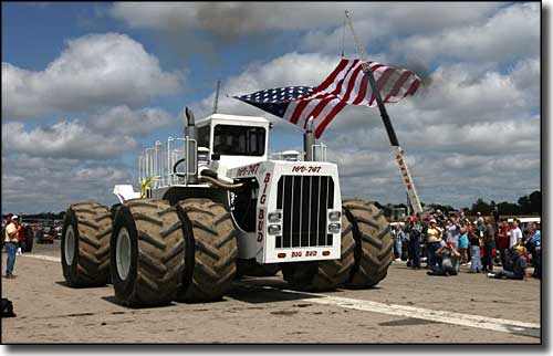
 Big Bud 747 works in the Big Sandy area, plowing about 1 acre per minute on a good day |

Big Sandy is where the Big Bud 747 (Planet Earth's largest farm tractor) calls home. The town is named for the nearby Big Sandy Creek. Originally, this was the site of a favorite saloon frequented by Missouri River freighters, built at a junction point on the Cow Island Trail between Virgelle, Fort Benton, Havre and Fort Assiniboine. The actual town began when the St. Paul, Minnesota & Manitoba Railway (which was later folded into the Great Northern Railway) arrived in 1887. Within a year of the railroad's arrival, Big Sandy had grown to accommodate two freight depots, a warehouse, a box car the railroad section foreman lived in and nine saloons (eight of which were in small shacks or tents with wooden floors). The Spokane Hotel was built in 1889 to serve the needs of the railroad men, new settlers and the many itinerant cowboys. The first store was opened in Big Sandy around 1900 by the operators of the McNamara Cattle Company. Homesteaders didn't start arriving until 1909, but once they started arriving, the flow was steady for the next decade. The first bank opened in town in 1910, then came merchants selling everything from lumber to farm implements to gasoline. Folks felt this was an auspicious location with the Missouri River Breaks to the south and the Bear Paw Mountains to the north: ideal for the growing of wheat and other grains. At one point, there were five grain elevators operating in Big Sandy. However, lands claimed under the Homestead Act were simply too small in size to grow enough crops to support folks and by 1919, many of the homesteaders had gone bust and left. One story as to how Big Sandy Creek got its name involves "Big Sandy" Lane, a famous muleskinner in the area. He was running some freight through the area but arrived beside the creek when it was at full flood. He started cursing: the weather, the creek, his own bad luck... as soon as his cursing rampage subsided, the creek dried up and he was able to get on with his business. Officially, the name is a translation of "Un-es-putcha-eka," the Blackfeet name for the creek which translates as "Big Sandy." For folks who want to float the Upper Missouri Wild and Scenic River, Coal Banks Landing is southwest of town and Judith Landing to the southeast. As of 2009, Big Sandy has seen a 14% drop in population since 2000. |
| Fast Facts about Big Sandy, Montana |
|
Big Sandy, Chouteau County, MT 59520
Elevation: 2,700' Latitude: 48.1779°N Longitude: 110.1146°W Resident Racial Breakdown: White Non-Hispanic: 95.3% Hispanic: 0.8% Native American: 1.0% Two or more races: 2.9% Education: High School or Higher: 81.6% Bachelor's Degree or Higher: 21.1% Graduate or Professional Degree: 6.5%
2009 Estimates: Population: 603 Males: 285 Females: 318 Median Resident Age: 47.7 Years Estimated Median Household Income: $30,900 Estimated Median Home Value: $69,700 Population Density: 1,362 People per Square Mile 2011 Cost of Living Index for Big Sandy: 86.1 Major Industries: Agriculture, Educational Services, Health Care, Lodging & Food Services, Construction, Religious Organizations, Government, Finance & Insurance Services, Building Materials Unemployed (March 2011): 5.3% |
|
|
 |
| Index - Arizona - Colorado - Idaho - Montana - Nevada - New Mexico - Utah - Wyoming National Forests - National Parks - Scenic Byways - Ski & Snowboard Areas - BLM Sites Wilderness Areas - National Wildlife Refuges - National Trails - Rural Life Advertise With Us - About This Site - Privacy Policy |
| Photo of the Big Bud 747 courtesy of Myron Reynard, CCA ShareAlike 3.0 License. Text Copyright © by Sangres.com. All rights reserved. |