 |
Hewitt Lake National Wildlife Refuge |
|
Hewitt Lake National Wildlife Refuge is a 1,680-acre property that is only half federally-owned. The remainder of the acreage is held as a conservation easement with local landowners. The property was set aside as a designated protected area for the nesting, resting and breeding purposes of migratory waterfowl and other wildlife. Hewitt Lake itself is a small, shallow lake that is actually quite alkaline and is sometimes completely dry. It supports very little aquatic vegetation except near the earthen dam on the east end of the lake. Resource management is confined to maintaining the primary dam while there are some proposed fencing projects (to stop trespass grazing) on the table. Access is via a county gravel road that crosses the main dam and then travels west along the north boundary of the property. The federally-owned portion of Hewitt Lake NWR is open to waterfowl hunting in the appropriate seasons but hunting the easement portion requires written permission from the landowner(s) involved. All other hunting is not permitted. Hewitt Lake NWR is within the Bureau of Land Management's Big Bend of the Milk River Area of Critical Environmental Concern. There are some old, large Native American encampment sites and bison kill areas in the neighborhood. Hewitt Lake NWR is part of the Bowdoin Wetland Management District and is administered out of the office at Bowdoin National Wildlife Refuge. The property is unstaffed and offers essentially no visitor improvements. To get there: 18 miles east of Malta on US Highway 2, turn north on CR 243. Go about 5 miles, then turn left on the gravel road that crosses the Nelson Reservoir Dam. Go another 2 miles to the dam at Hewitt Lake. |
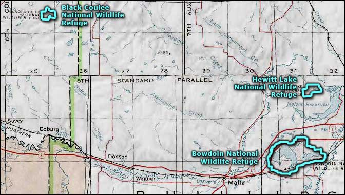 Hewitt Lake National Wildlife Refuge area map |
|
|

|
| Index - Arizona - Colorado - Idaho - Montana - Nevada - New Mexico - Utah - Wyoming National Forests - National Parks - Scenic Byways - Ski & Snowboard Areas - BLM Sites Wilderness Areas - National Wildlife Refuges - National Trails - Rural Life Advertise With Us - About This Site - Privacy Policy |
| Map courtesy of National Geographic Topo! Text Copyright © by Sangres.com. All rights reserved. |