Carson National Forest Campgrounds

The list below is of developed campgrounds within the Carson National Forest. A lot of them are managed by private concessionaires who charge fees for their maintenance and management. However, while some restrictions apply, we can camp almost anywhere in the forest. We do have to be careful, though, because many thousands of us humans visiting the forest can cause quite an impact on the land, the vegetation, the streams and ponds, the mountains, and the wildlife. But if we minimize all traces of our visits, that which the forest seeks to preserve will be preserved and future generations will never know we were here.
Camping limit in any one spot is 14 days. Preferred campsites are at least 200 feet from any water source, have a spot for a tent that doesn't destroy any vegetation (better yet: try a hammock with a tarp instead of a tent), and is out of sight of a trail (unless it is a designated campsite). You might also wear sneakers or light shoes to avoid trampling the vegetation. Instead of a campfire, try using a portable stove (it leaves no unsightly scars on the landscape and never burns out of control). If you must have a fire: keep it small and use only fallen, dead wood. You don't need a fire ring but you do want to clear away anything burnable for several feet around your fire. Never leave your fire unattended and make sure it's not just dead out when you leave but make all trace of it disappear.
The closer you get to the source of the water, the cleaner and purer it will be. That said, giardia lambia and other water-borne parasites are still present in places in the forest and you never know... you'll probably want to filter or treat all your drinking water. But if you happen to get lost and are in trouble with no water, drink from a free flowing stream: far too many lost folks are found dead next to streams that have perfectly good water, killed by the propaganda that says EVERY STREAM... it's not true. A few years ago a Forest Ranger went around testing stream water all over the Rockies and his published report stated there are more giardia cysts in Denver City tap water than in most streams he tested (the cysts are extremely durable but it takes a particular threshold amount of them in your system to make you sick). Again, the closer you are to the source of flowing water, the cleaner and purer the water will be.
For your feces, dig a hole 5-6 inches deep into the soil humus and bury everything when you are done. Be at least 200 feet from any water. Don't leave any trash anywhere: pack it in, pack it out.
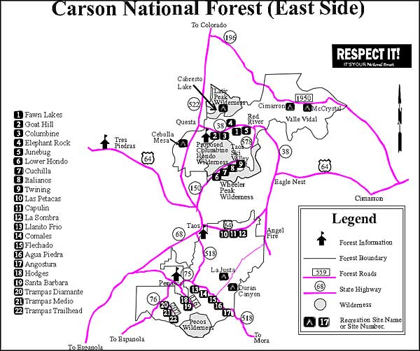
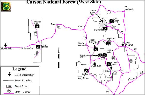
| Campground Name | General Area | Elevation | # units | Season | Facilities |
|---|---|---|---|---|---|
| Cimarron * | Valle Vidal/Questa | 9,400 | 35 | May-Oct | |
| McCrystal * | Valle Vidal/Questa | 8,100 | 60 | May-Nov | |
| Elephant Rock * | Red River Canyon/Questa | 8,500 | 21 | May-Sept | |
| Fawn Lakes * | Red River Canyon/Questa | 8,500 | 18 | May-Oct | |
| Goat Hill * | Red River Canyon/Questa | 7,500 | 5 | May-Dec | |
| Junebug * | Red River Canyon/Questa | 8,500 | 20 | May-Sept | |
| Columbine * | Red River Canyon/Questa | 7,900 | 27 | May-Sept | |
| BLM Wild River | Rio Grande Gorge | 7,300 | 35 | All Year | |
| Cebolla Mesa | Rio Grande Gorge/Questa | 7,300 | 5 | May-Oct | |
| BLM Orilla Verde | Rio Grande Gorge | 7,300 | 23 | All Year | |
| Cabresto Lake | Latirs/Questa | 9,500 | 9 | May-Sept | |
| Cuchilla | Rio Hondo/Questa | 7,800 | 3 | May-Sept | |
| Lower Hondo | Rio Hondo/Questa | 7,700 | 4 | May-Sept | |
| Twining | Rio Hondo/Questa | 9,300 | 4 | May-Sept | |
| La Sombra | Taos Canyon/Camino Real | 7,800 | 13 | May-Oct | |
| Capulin | Taos Canyon/Camino Real | 8,000 | 11 | May-Oct | |
| Las Petacas | Taos Canyon/Camino Real | 7,400 | 9 | May-Nov | |
| Agua Piedra * | Rio Pueblo/Camino Real | 8,100 | 44 | May-Oct | |
| Comales * | Rio Pueblo/Camino Real | 7,800 | 13 | May-Oct | |
| La Junta Canyon * | Rio Pueblo/Camino Real | 9,400 | 30 | May-Oct | |
| Duran Canyon * | Rio Pueblo/Camino Real | 9,000 | 12 | May-Oct | |
| Santa Barbara * | North Pecos/Camino Real | 8,900 | 21 | May-Oct | |
| Lagunitas | Tres Piedras | 10,400 | 14 | June-Oct | |
| Los Pinos | Tres Piedras | 8,300 | 5 | June-Sept | |
| Canjilon Lakes * | Canjilon | 9,900 | 40 | June-Sept | |
| Canjilon Creek | Canjilon | 9,300 | 4 | June-Sept | |
| Trout Lakes | Canjilon | 9,300 | 12 | June-Sept | |
| El Rito Creek | El Rito | 7,600 | 11 | April-Nov | |
| Buzzard Park | Gobernador/Jicarilla | 7,300 | 4 | May-Nov | |
| Cedar Springs | Gobernador/Jicarilla | 7,300 | 4 | May-Nov | |
| * Site managed by Concessionaire | |||||


