 |
Northwest Passage Scenic Byway |
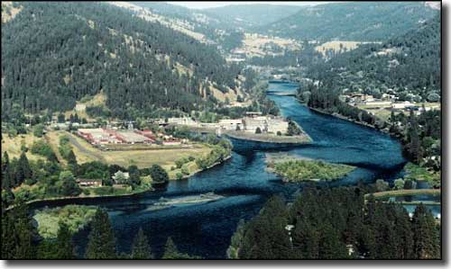
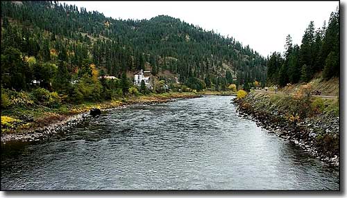 The Clearwater River near Greer |
The Northwest Passage Scenic Byway follows US Highway 12 for about 202 miles (including a spur on Idaho Route 13 to Grangeville), from the Montana border at Lolo Pass to the Snake River at Lewiston. This is primarily the route followed by Lewis & Clark and the Corps of Discovery more than 200 years ago as they searched for an easy route to the Pacific Ocean. Most of the countryside traversed by this Scenic Byway is little changed from those days: the forests are still green, the rivers clear and the mountains rugged. Lewis and Clark had first entered Idaho from Montana further to the south and tried to use the Salmon River as a route through the Idaho mountains, but they were defeated by the ruggedness of the countryside and recrossed the top ridge of the Bitterroots back into Montana. Then they headed north and found their way to Lolo Pass. Just below Lolo Pass is the Lochsa River, and they followed that down to the Clearwater and then the Clearwater down to the Snake. There are Lewis & Clark National Historic Trail Visitor Centers with exhibits and displays that go into the whole story (and more) at both ends of the Northwest Passage Scenic Byway (Lewiston and Lolo Pass), with a major stop, kiosk and interpretive center at Kooskia and another at Grangeville. This countryside was the homeland of the Nez Perce tribe for many, many years. As you drive the Northwest Passage Scenic Byway, you'll come across numerous Nez Perce historical sites (including the Nez Perce National Historic Park sites at the Spalding Mission and at East Kamiah) and numerous Lewis & Clark historic sites. Orofino is near the site of the first gold strike in Idaho (1860). This journey through the heart of Idaho's mountains and forests is also alongside some of America's premier whitewater rafting streams. One of Idaho's few nationally designated Wild and Scenic Rivers, the Lochsa River (lochsa means "rough water") offers 40 sets of rapids rated as Class IV and above. The Clearwater offers stunning scenery with moderate rapids and deep canyons. The nearby Salmon River is also known as the "River of No Return" (for good reason). But if risking life and limb in churning whitewater is not your thing, how about world-class fishing for steelhead, salmon, bass, cutthroat and rainbow trout, even Hells Canyon White Sturgeon? 
There is a spur route on Idaho Highway 13 from Kooskia to Grangeville. This spur takes you up and out of the Clearwater Canyon and onto the Camas Prairie, a very fertile agricultural region that also has many historic and cultural sites, mostly revolving around the history and lifestyle of the Nez Perce. In the mountains near Grangeville is the Snow Haven Ski Area and the Gospel-Hump Wilderness. Elmers Park and Visitor Center is also in Grangeville. At Elmers Park you'll find a nice exhibit of a complete Tolo Lake mammoth skeleton. You can also get directions there to vist the Nez Perce National Historic Park sites at Tolo Lake, Weis Rockshelter and White Bird Battlefield. Just north of Kooskia is Kamiah, site of Lewis & Clark's Long Camp, a time when they spent 6 weeks camped with the Nez Perce in 1806 as they were heading back east after reaching the Pacific Ocean. At Kamiah is "the Heart of the Monster," a geologic formation that figures prominently in Nez Perce creation stories and legends. At Riverfront Park in Kamiah is an interpretive kiosk that commemorates the six-weeks that Lewis & Clark spent camped with the Nez Perce in 1806. "Long Camp" is directly across the river from the park. Near Orofino is where the Corps of Discovery felled the big Ponderosas they used to make the canoes that carried them down the Clearwater, down the Snake, down the Columbia to the Pacific. They did this at the site of a Nez Perce fishing village that had been occupied for more than 4,000 years. "Canoe Camp" is located on the banks of the Clearwater in Orofino. The Nez Perce taught Lewis & Clark how to build canoes here in the fall of 1805, just before the expedition set float on the Clearwater and headed downstream to the Pacific Ocean. Canoe Camp is managed as part of the Nez Perce National Historic Park and offers a sample dugout canoe and an interpretive trail through what remains of the old fishing area from 4,000 years ago. Dworshak Dam and Dworshak National Fish Hatchery are located across the Clearwater from Canoe Camp. The Lewis & Clark Discovery Center is four miles south of Lewiston in Hells Gate State Park. The Discovery Center offers sculptures, exhibits and video presentations pertaining to the 1805-6 journey of the Lewis & Clark Expedition across Nez Perce country. |
 The Clearwater River near Orofino 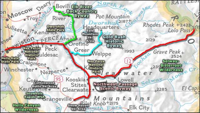 Northwest Passage Scenic Byway area map |
|
|
Northwest Passage Scenic Byway Related Pages
Gold Rush Historic Byway - Elk River Back Country Byway - Hells Gate State Park
Selway-Bitterroot Wilderness - Hells Canyon Wilderness - Dworshak State Park Cottonwood Butte Ski Area - Snowhaven Ski Area - Bald Mountain Ski Area Nez Perce National Historic Park - Snowhole Rapids Wilderness Study Area Idaho Pages |
 |
| Index - Arizona - Colorado - Idaho - Montana - Nevada - New Mexico - Utah - Wyoming National Forests - National Parks - Scenic Byways - Ski & Snowboard Areas - BLM Sites Wilderness Areas - National Wildlife Refuges - National Trails - Rural Life Advertise With Us - About This Site - Privacy Policy |
| Photo of the Clearwater River near Greer courtesy of the Idaho Department of Commerce and Labor. Photo of the Clearwater River near Orofino courtesy of DS Dugan. Area map courtesy of National Geographic Topo! Text Copyright © by Sangres.com. All rights reserved. |