Dubois, Wyoming

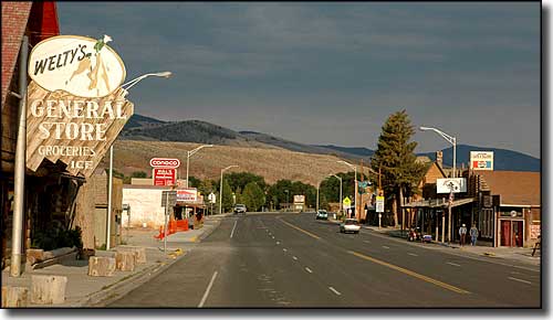
Main Street in Dubois
Dubois is located on the Wind River in northwestern Lander County, surrounded on three sides by the Shoshone National Forest (2.4 million acres, of which 1.5 million acres is designated wilderness). This is on one of the Yellowstone National Park access roads in the Upper Wind River Valley, an area of world-class trout streams amid big wilderness areas. The Absaroka Mountains are north of town and the Wind River Range is to the south. Just southeast of Dubois in Whiskey Basin is one of the largest herds of Bighorn sheep in America, that's why the National Bighorn Sheep Interpretive Center is here.
Native Americans and fur traders knew this country well, then the homesteaders arrived and settled the town in the late 1800's. Butch Cassidy spent a fall and a winter near Dubois before setting off on his biggest crime spree. Then Scandinavian loggers were brought in and from 1914 to 1946, they produced more than 10 million hand-hewn railroad ties for the Wyoming Tie and Timber Company. A wooden flume was built to carry the ties from the mountains to the Wind River where they were floated 100 miles downstream in massive weeks-long drives to Riverton, then they were removed from the river and placed on railroad cars. As hard as these guys worked, they also played. They left many exploits and local legends that are still talked about in the watering holes of Dubois. There's even one story about Whiskey Mountain (and Basin) getting the name from a group of cowboys who lost their whiskey stash in a creek nearby.
Dubois is named after Fred Dubois, a former Senator from Idaho. The previous name was "Never Sweat" (because of the area's warm, dry winds), but the postal service objected to that and forced the name change. Today, Dubois bills itself as the place "Where Real Cowboys Work and Play."
In the winter, you'll find more than 150 miles of groomed snowmobile trails that access the Continental Divide Snowmobile Trail, itself about 360 miles of trails between Yellowstone and Lander that connect to another 665 miles of groomed trails scattered through the area.
Latitude: 43.5359°N
Longitude: 109.6359°W
Elevation: 6,946'
Education:
High School or Higher: 89.8%
Bachelor's Degree or Higher: 16.3%
Graduate or Professional Degree: 4.3%
2011 Cost of Living Index for Dubois: 82.5
Median Resident Age: 44.3 Years
Estimated Median Household Income: $40,500
Estimated Median Home Value: $150,300
Population Density: 419 People per Square Mile
Major Industries:
Lodging & Food Services, Construction, Educational Services, Forestry, Agriculture, Health Care, Real Estate Services, Retail Services, Government
Unemployed (March 2011): 8.1%
Population Demographics: 2010
| Total Population | 971 |
| Males | 485 |
| Females | 486 |
| Population by Age | |
| Under 18 | 134 |
| 18 & over | 837 |
| 20-24 | 34 |
| 25-34 | 78 |
| 35-49 | 193 |
| 50-64 | 269 |
| 65 & over | 244 |
| Population by Ethnicity | |
| Hispanic or Latino | 4 |
| Non Hispanic or Latino | 967 |
| Population by Race | |
| White | 930 |
| African-American | 4 |
| Asian | 12 |
| Native American | 9 |
| Hawaiian or Pacific Islander | 0 |
| Other | 2 |
| Two or more | 14 |
Bridger-Teton National Forest - Shoshone National Forest
Fitzpatrick Wilderness - Popo Agie Wilderness - Washakie Wilderness
Centennial Scenic Byway - Wind River Canyon Scenic Byway
Boysen State Park - Sinks Canyon State Park
