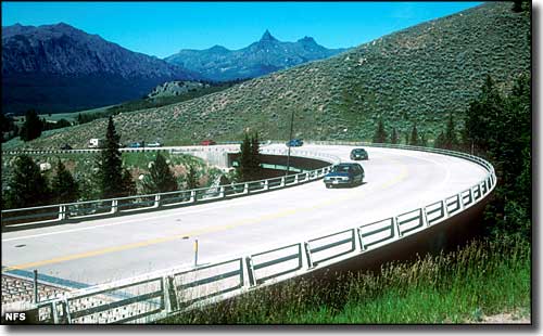
Charles Kurault once called the Beartooth Highway, "America's most beautiful highway." The Beartooth Highway covers about 69 miles along US Highway 212 between Red Lodge and Cooke City, Montana. This is some absolutely spectacular countryside among the Absaroka and Beartooth Mountains near the northeastern corner of Yellowstone National Park.
The route travels through the Custer, Shoshone and Gallatin National Forests. The stretch of highway between Red Lodge, Montana, and Wyoming Highway 296 (the Chief Joseph Scenic Highway) is closed in winter by snow. But when that road is open, this is an incredible way to make the drive to the northeastern entrance of Yellowstone National Park.
For many miles along the road you'll have the Absaroka-Beathtooth Wilderness to the north and the North Absaroka Wilderness to the south. This is high mountain country with lots of wildlife out and about.
The route of the Beartooth Highway was originally built by soldiers under the command of General Philip Sheridan when he was in charge of Yellowstone National Park. In order to carry out his mission of protecting the park and preserving what was still left of its natural wonders, his men built the trail in 1888 to bring supllies overland from Red Lodge, Montana. The highway we see today was first widened and paved in the 1930's and finally opened to vehicular traffic in 1936.

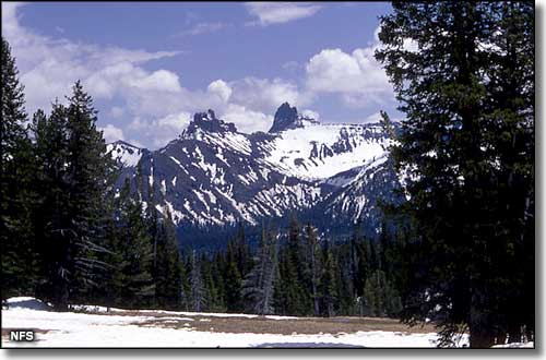
East of Gardiner, Montana on the Beartooth Highway, Pilot and Index Peaks in the background

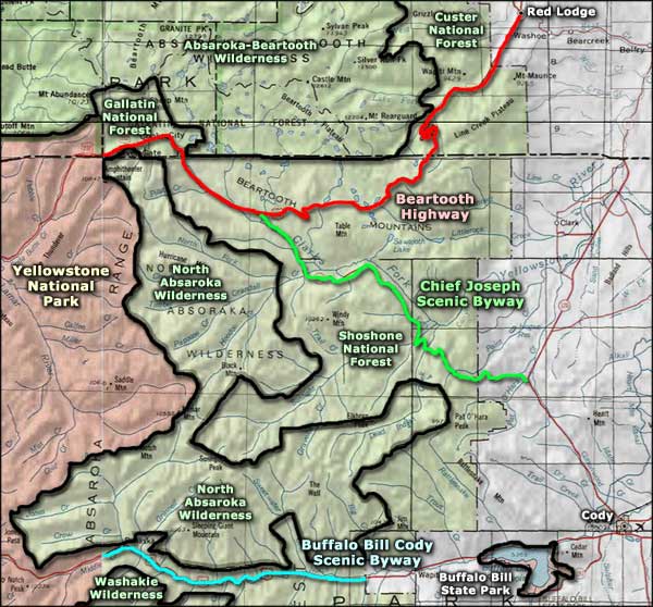
Beartooth Highway area map
Campground
|
# of Units
|
Max. Trailer Length
|
Season
|
Elevation
|
Campground Host or Concessionaire
|

|

|
Comments
|
Sheridan - 6 mi S. of Red Lodge (reservable)
|
8
|
30'
|
May to Sept
|
6,300'
|
Concessionaire
|
1 hand pump
|
$12
|
There is a charge of $8 per additional vehicle. Day use fee of $6 over 1/2 hr.
|
Rattin - 8 mi S. of Red Lodge (reservable)
|
6
|
25'
|
May to Sept
|
6,400'
|
Concessionaire
|
1 hand pump
|
$12
|
There is a charge of $8 per additional vehicle. Day use fee of $6 over 1/2 hr.
|
Parkside - 12 mi S. of Red Lodge (reservable)
|
28
|
45'
|
May to Sept
|
7,300'
|
Concessionaire
|
2 hand pumps
|
$12
|
There is a charge of $8 per additional vehicle. Day use fee of $6 over 1/2 hr.
|
Limber Pine - 12 mi S. of Red Lodge (reservable)
|
13
|
45'
|
May to Sept
|
7,200'
|
Concessionaire
|
1 hand pump
|
$12
|
There is a charge of $8 per additional vehicle. Day use fee of $6 over 1/2 hr.
|
Greenough Lake - 12 mi S. of Red Lodge (reservable)
|
18
|
50'
|
May to Sept
|
7,300'
|
Concessionaire
|
1 hand pump
|
$12
|
There is a charge of $8 per additional vehicle. Day use fee of $6 over 1/2 hr.
|
M-K - 12 mi S. of Red Lodge
|
10
|
22'
|
May to Sept
|
7,500'
|
-
|
-
|
-
|
No services. Fishing and hiking nearby.
|
| Shoshone National Forest - 307-527-6921
|
Island Lake - 29 mi S. of Red Lodge
|
20
|
32'
|
July to mid-Sept
|
9,600'
|
Campground Host
|
-
|
$10
|
Boat ramp, fishing, trailhead, wilderness access, store nearby
|
Beartooth Lake - 31 mi S. of Red Lodge
|
20
|
32'
|
July to mid-Sept
|
9,000'
|
Campground Host
|
2 hand pumps
|
$15
|
Boat ramp, fishing, trailhead, store nearby, picnic area
|
Crazy Creek - 11 mi E. of Cooke City
|
16
|
32'
|
May to Sept
|
6,900'
|
Campground Host
|
-
|
$10
|
Stream fishing nearby, trailhead, scenic walk to waterfall
|
Fox Creek - 7 mi E. of Cooke City
|
27
|
50'
|
May to Sept
|
7,100'
|
Campground Host
|
X
|
$20
|
Water and power hookups at sites. Double and triple sites available
|
| Gallatin National Forest - 406-848-7375
|
Chief Joseph - 4 mi E. of Cooke City
|
6
|
42'
|
Mid-June to end of Sept
|
7,400'
|
-
|
X
|
$8
|
$3 charge per additional vehicle.
|
Colter - 2 mi E. of Cooke City
|
23
|
32'
|
Closed
|
7,400'
|
-
|
X
|
$8
|
|
Soda Butte - 1 mi E of Cooke City
|
21
|
48'
|
July to mid-Sept
|
7,400'
|
-
|
X
|
$9
|
$3 charge per additional vehicle
|


