Parker, Arizona

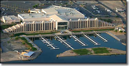
The Bluewater Resort and Casino in Parker, Arizona
On January 6, 1871, the Parker Post office was established on the Colorado River Indian Reservation. It was named so in honor of General Ely Parker, Commissioner of Indian Affairs when the Colorado River Indian Reservation was established by Congress in 1865.
A railroad was built through the area in 1905 and the Parker Post Office was then moved 4 miles upstream to the railroad. The townsite of Parker wasn't surveyed and platted until 1909, by a railroad location engineer named Earl H. Parker. The Federal Government started auctioning building lots in Parker in 1910. In those days Parker served as a railroad stopover and watering and shipping station. The town grew up to serve mining and agricultural interests in the area. Slowly the mining died out and agriculture grew more and more important. Parker Dam was built in 1928, creating a reservoir that was mostly to feed water to the southern California cities. Headgate Rock Dam was built in 1941 and that led to a stable source of irrigation water for the local area. By 1955, some 38,000 acres were being irrigated and farmed. Cotton was the big crop and cotton gins were built in Parker.
Technically, Parker consists of two non-contiguous pieces of land: one developed area within the Colorado River Indian Reservation, the other was annexed into Parker in 1980 and is to the south and east, a roughly rectangular 13,000-acre area of mostly undeveloped land just east of the Colorado River Indian Reservation boundary.
Latitude: 34.1446°N
Longitude: 114.2897°W
Founded: 1908; Incorporated: 1948
Elevation: 423'
Education:
High School or Higher: 70.4%
Bachelor's Degree or Higher: 15.5%
Graduate or Professional Degree: 5.4%
2011 Cost of Living Index for Parker: 84.6
Estimated Median Household Income: $36,400
Estimated Median Home Value: $151,000
Median Resident Age: 32.4 Years
Major Industries:
Educational Services, Government, Lodging & Food Services, Health Care, Arts, Entertainment & Recreation, Agriculture, Social Services, Construction, Utilities, Finance & Insurance Services
Unemployed (March 2011): 10.5%
2010 Population Demographics
| Total Population | 3,083 |
| Males | 1,615 |
| Females | 1,468 |
| Population by Age | |
| Under 18 | 847 |
| 18 & over | 2,236 |
| 20-24 | 255 |
| 25-34 | 448 |
| 35-49 | 533 |
| 50-64 | 594 |
| 65 & over | 315 |
| Population by Ethnicity | |
| Hispanic or Latino | 1,293 |
| Non Hispanic or Latino | 1,790 |
| Population by Race | |
| White | 1,370 |
| African-American | 44 |
| Asian | 26 |
| Native American | 635 |
| Hawaiian or Pacific Islander | 2 |
| Other | 813 |
| Two or more | 193 |
